Cloud‑Free Deforestation Monitoring
Frequent, cloudless composites to detect and document forest loss, even through rainy seasons.
Trusted by leading organizations
The Cloudy Challenge
Illegal clearing often coincides with cloudy seasons, delaying alerts when response time matters most. Patchy imagery weakens evidence chains, complicates MRV programs, and risks non‑compliance with procurement and zero‑deforestation pledges. Analysts need consistent, cloud‑free composites to separate seasonal variability from true canopy loss and to build defensible incident timelines.
- Persistent cloud cover
- Broken / delayed time-series
- Weak audit evidence
Our Solution
ClearSKY fuses optical and SAR satellites using artificial intelligence to reconstruct complete, Sentinel-2 compatible images. You get cloud-free, analysis-ready data via dashboard or API, so you can focus on decisions, not cloud, shadows and image gaps. Tighten alerting, build traceable cases, and back claims with clear, date‑stamped mosaics.
- Early‑warning views
- Defensible evidence
- Scales wide
Clouds out, decisions in!
Consistent, frequent, gap-free views for hard to reach places.
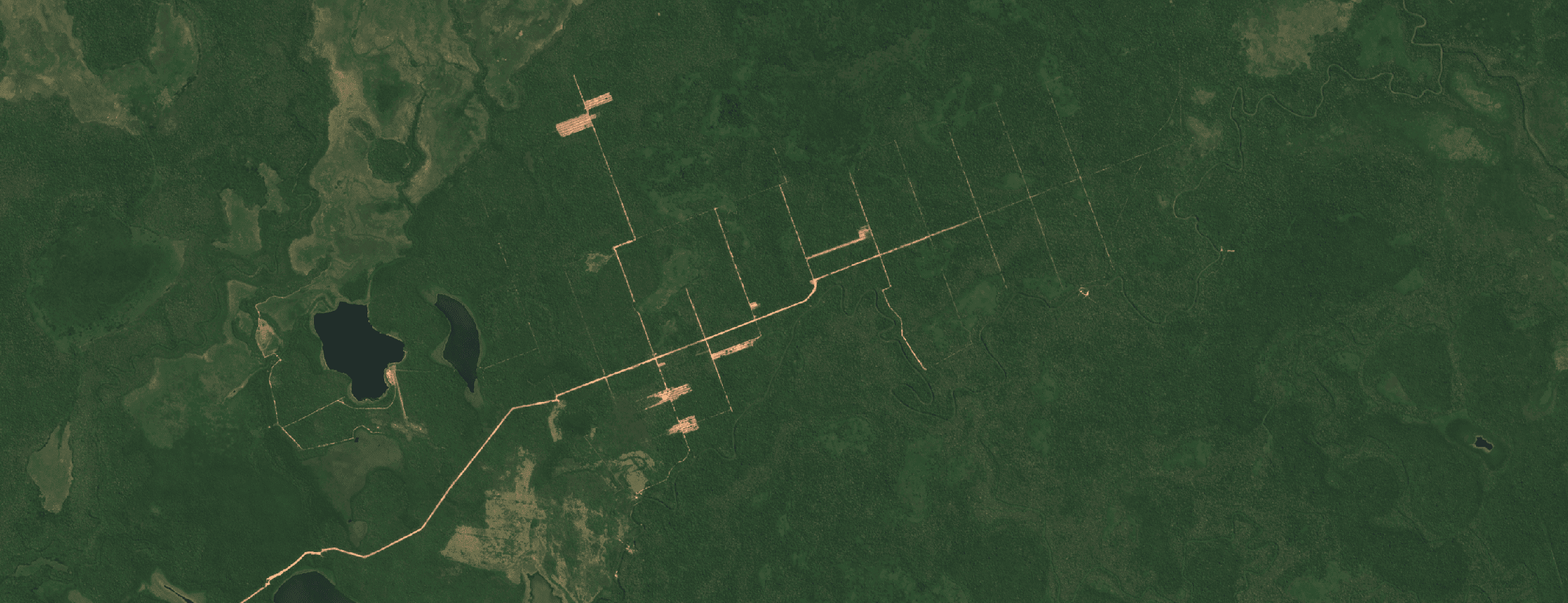
Ascencion De Guarayos, Bolivia · Aug 2024 · 10 m bands (S2-compatible)
How it works
Fuse
We combine optical + SAR and other sensors to remove clouds, shadows and gaps.
Deliver
Get Sentinel-2 compatible tiles or composites through API or dashboard.
Analyze
Use analysis-ready pixels immediately. No masking or stitching required.
Why ClearSKY for Deforestation
AI-Powered Fusion
Combine optical & SAR for cloud-free mosaics.
Reliable Cadence
Daily to weekly updates.
Fits Your Workflow
Tiles, composites, API, or dashboard.
Analysis Ready
No masking or gap-filling needed.
Enterprise Support
Stable service with responsive help.
Scales Globally
From small plots to regions.
Start with a free trial
Explore cloud-free, analysis-ready imagery in our dashboard. Switch to the API when you’re ready.